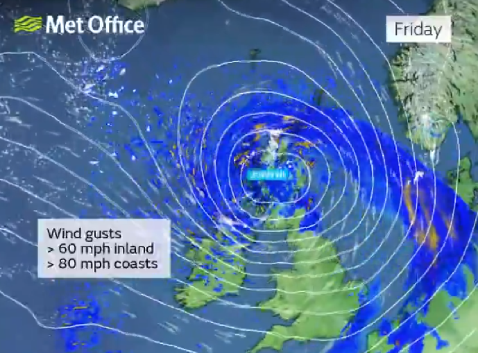
Storm Éowyn has been named and is forecast to bring strong winds on Friday and into Saturday.
The Met Office says the storm is expected to pass close to or across the northwest of Scotland on Friday before clearing to the northeast on Saturday.
An update yellow warning of strong winds has been extended across much of the UK and is in place over Friday until 3pm on Saturday.
Whilst there is some uncertainty in the track of Éowyn, a spell of very strong winds
is likely, initially southeasterly before turning westerly, with peak gusts of 50-60
mph inland, 60-70 mph around some coasts and hills, and perhaps up to 80 mph in exposed
parts of western Scotland.
Strong west to northwesterly winds will continue through the first part of Saturday
as Storm Éowyn moves to the northeast, with gusts of 50-60 mph inland and 60-70 mph
over some exposed coasts and hills. There is a small chance of 70-80 mph gusts across
the Northern Isles for a time.
Winds will ease across southern parts of the warning area during the early hours of Saturday, and this easing in wind strength will expand northwards through the day on Saturday.
Power cuts are likely to occur, with the potential to affect other services, such as mobile phone coverage
Road, rail, air and ferry services are likely to be affected, with longer journey times and cancellations possible. Some roads and bridges will close
There is a chance that damage to buildings and homes could occur, with roofs blown off and power lines brought down
Injuries and danger to life could occur from flying debris, as well as large waves and beach material being thrown onto sea fronts, coastal roads and properties

Storm Éowyn named as strong winds and heavy rain forecast
21 January 2025