Strong winds up to severe gale force are set to batter the Western Isles on Friday says the Met Office.
An area of low pressure positioned to the north and east of the UK through the coming days will bring a cold northerly wind that will push rain and showers southwards at times.
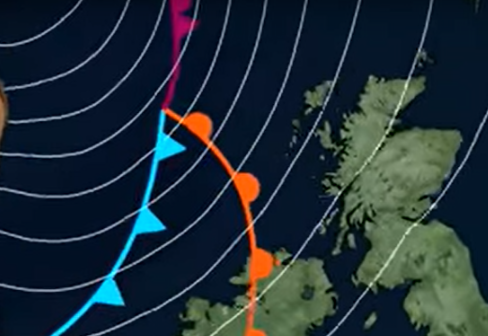
By the end of the week a new and deeper area of low pressure will arrive from the northwest potentially bringing a more notably unsettled spell of weather for Friday.
The strongest winds expected to affect the Hebrides and north west coast of Scotland with the potential for severe gales, up to 55 mph, on Friday morning and afternoon and spells of heavy rain.
Chief meteorologist Steven Ramsdale said: “The start of the week has certainly seen a change in the weather as cool air and bands of rain and showers have swept southwards.
“Much of the next few days will see similar conditions across the UK and although it’ll feel cooler and breezier than recently, this is fairly typical autumn weather for us.”
Daniel Rudman, deputy chief meteorologist at the Met Office said: “On Friday it looks as though a deeper area of low pressure will move into the northwest of the UK.
“This means that many can expect a more notably wet and windy spell, for a time on Friday, than we’ve seen so far this autumn. However, this is nothing unusual for the time of year.”
There is good confidence in the general trend for a cooler and unsettled week, however the details may vary.
He added: “At this time of year, knock-
Severe gales forecast for Friday
28 September 2022